Page 28 - EETEurope FlipBook February
P. 28

28 EE|Times EUROPE — CES 2021
               Data Drives Agriculture 4.0


               and drone company, for US$23 million. Mica-
               Sense developed a camera that uses different
               wavelengths to compute normalized difference
               vegetation index (NDVI) maps, which have
               become the accepted way to monitor crop
               growth and spot problem areas. The state-of-
               the-art methodology is now to download the
               NDVI maps to tractors and thereby adjust the
               fertilizers delivered to the field.
                 The U.S. Federal Aviation Administration
               (FAA) recently reported that 7% of the
               1.6 million registered drones in the U.S.
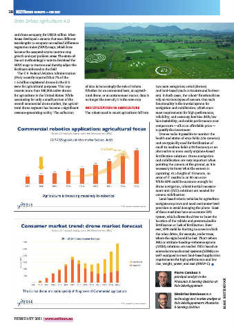
               were for agricultural purposes. This rep-  of data is increasingly the role of robots.   two main categories: aerial (drones)
               resents more than 100,000 active drones   Whether for an automated barn, an agricul-  and land-based (such as tractors and harvest-
               for agriculture in the United States. While   tural drone, or an autonomous tractor, data is   ers). In both cases, the robots’ functionalities
               accounting for only a small portion of the   no longer the new oil; it is the new crop.  rely on various types of sensors. One such
               overall commercial drone market, the agricul-                           functionality is the inertial system for
               tural drone segment has become a significant    IMU UTILIZATION IN AGRICULTURE  navigation and stabilization, which must
               revenue-generating reality. The collection   The robots used in smart agriculture fall into   meet requirements for high performance,
                                                                                       reliability, and accuracy; low bias drift; low
                                                                                       bias instability; and stable performance over
                                                                                       temperature — all at an affordable price —
                                                                                       to justify the investment.
                                                                                         Drones make it possible to monitor the
                                                                                       health and status of crop fields (via cameras)
                                                                                       and are typically used for fertilization of
                                                                                       small to medium fields (<20 hectares) as an
                                                                                       alternative to more costly airplane-based
                                                                                       fertilization solutions. Drone navigation
                                                                                       and stabilization are very important when
                                                                                       pointing the camera at the ground, as it is
                                                                                       necessary to know what the camera is
                                                                                       capturing. At a height of 10 meters, an
                                                                                       error of 5° results in an 80-cm error.
                                                                                       While GPS could be accurate enough for
                                                                                       drone navigation, robust inertial measure-
                                                                                       ment unit (IMU) solutions are needed for
                                                                                       camera stabilization.
                                                                                         Land-based robotic vehicles for agriculture
                                                                                       navigate crop rows and need centimeter-level
                                                                                       precision to avoid damaging the plants. Most
                                                                                       of these machines have an accurate GPS
                                                                                       system, which allows the driver to know the
                                                                                       location of the vehicle and prevents double
                                                                                       fertilization or lack of fertilization. How-
                                                                                       ever, GPS could be limiting in cases in which
                                                                                       the robot drives, for example, under trees,
                                                                                       where the signal could be lost. That’s where
                                                                                       IMU or attitude-heading–reference system
                                                                                       (AHRS) solutions are needed. IMUs based on
                                                                                       microelectromechanical systems (MEMS) are
                                                                                       well-equipped to meet land-based application
                                                                                       requirements for high performance and low
                                                                                       size, weight, power, and cost (SWAP-C). ■
                                                                                                Pierre Cambou is
                                                                                                principal analyst in the
                                                                                                Photonics & Sensing Division at
                                                                                                Yole Développement.

                                                                                                Dimitrios Damianos is a    IMAGE: SHUTTERSTOCK
                                                                                                technology and market analyst at
                                                                                                Yole Développement’s Photonics
                                                                                                & Sensing Division.


               FEBRUARY 2021 | www.eetimes.eu
   23   24   25   26   27   28   29   30   31   32   33